
DGGS is seeking geophysics survey partners
North of 60 Mining News – June 21, 2019
Last updated 9/25/2020 at 5:05pm
Alaska Division of Geological & Geophysical Surveys
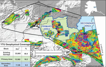
The DGGS intends to gather geophysical data from a primary area extending roughly 125 miles east of Fairbanks and a secondary area north of the Fortymile Mining District.
The Alaska Division of Geological & Geophysical Surveys June 7 announced that it is seeking partners to share the costs and results of airborne magnetic and radiometric geophysical surveys planned to be flown this summer over the Yukon-Tanana uplands of eastern Alaska.
The survey intends to gather data from a 5,236-square-mile (13,562 square kilometers) primary area extending roughly 125 miles (200 kilometers) east of Fairbanks; and, if funding allows, a 2,751-square mile (7,126 square kilometers) secondary area north of the Fortymile Mining District.
DGGS Director Steve Masterman said the division has some latitude to modify the survey to meet the needs of a partner and contributor to the program.
Current plans are for a regional fixed-wing magnetic survey with 300- or 400-meter line spacing and terrain drape. Weather permitting, DGGS also anticipates collecting radiometric data at the same time as the magnetic data. Surveys will be optimized for magnetic data acquisition with localized radiometric data acquisition.

As with previous private-public partnerships in geophysical data collection, DGGS requires all acquired airborne data to be integrated into the DGGS survey and to be concurrently made available publicly. DGGS wants to maximize the utility of this survey and be responsive to user needs and will keep confidential any discussions regarding additional data collections and areas of interest.
Masterman said DGGS is currently in the planning phase for the survey and is seeking parties interested in helping to broaden the spatial coverage or increase the level of detail in specific areas of interest.

Anyone interested in discussing additional or enhanced magnetic or radiometric data collection over specific areas within, or next to, the target areas may contact Abraham Emond, a geophysicist with DGGS, at [email protected] or 907-451-3098.
–SHANE LASLEY
Reader Comments(0)