

By Shane Lasley
Mining News
Tectonic kicks off 2020 Alaska drilling
Will test gold discovery targets at Tibbs, then Seventymile North of 60 Mining News – July 24, 2020
Last updated 8/6/2020 at 4:27pm

Shane Lasley
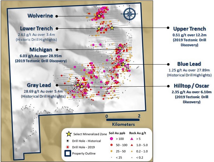
Tectonic Metals' exploration camp at Tibbs sits on the northeast end of the Michigan zone, where one hole drilled last year cut 29 meters averaging 6 grams per metric ton gold.
Tectonic Metals Inc. July 20 announced that drills are turning on its Tibbs Gold project less than 22 miles (35 kilometers) from Northern Star Resources Ltd.'s high-grade Pogo Gold Mine in Alaska's Goodpaster Mining District. Immediately following a roughly 2,500-meter rotary air blast drill program at Tibbs, Tectonic will launch the first drill program in more than two decades at Seventymile , an eastern Alaska gold project that covers a more than 25-mile- (40 kilometers) long greenstone belt.
"Drilling creates value, yet it can also destroy value. As part of our business model, we assess the risk versus the reward versus the cost of capital to execute a drill program before making any decision," said Tectonic Metals President and CEO Tony Reda. "Given our strong treasury in conjunction with the compelling targets, and the untapped potential at our Tibbs and Seventymile projects, the Tectonic team has unanimously concluded that we must move forward with two drill programs this summer."
The 2020 risk-versus-rewards decision making process, however, also had to take COVID-19 into consideration.
"Health and safety are always at the forefront of our minds, and even more so now," said Reda. "We have a robust, COVID-19 mitigation plan in place to protect our employees, contractors, and the communities in which we work, and are excited to provide our shareholders exposure to two potentially game-changing drill programs."
Tibbs drilling underway
The 2020 program at Tibbs is starting at the Michigan zone, where Tectonic's 2019 discovery drilling cut 28.95 meters averaging 6.03 grams per metric ton gold, before testing other Michigan-style structures along a 3,000-meter-long prospective corridor.
"The truth machine is currently hard at work at our Tibbs project following up on last year's drill intercept of roughly 6 g/t gold over 29 meters," said Reda. "It will work through at least three exciting discovery-stage targets at Tibbs before moving to our Seventymile Project for our first-ever drill program on this underexplored greenstone belt."
The targets being tested this year at Tibbs are:
Michigan Zone – Drilling will test the strike extent of the Michigan corridor by stepping out on regular intervals to the northeast and southwest from a fence of four holes drilled last year, all of which cut gold mineralization. This mineralization is hosted by a northeast-trending structure, newly interpreted by Tectonic to dip steeply to the northwest, that has not been adequately tested along strike.
Upper and Lower Trench Zone – Located about 1,500 meters northwest of Michigan, Upper and Lower Trench hosts a 1,000-by-600-meter gold-in-soil anomaly where rock grab samples, some with visible gold, have returned assays as high as 135 g/t gold. This year's drilling at Upper and Lower Trench is planned to test "Michigan-style" mineralization observed at surface, in historic drill core and in RAB drilling completed by Tectonic last year.
Wolverine Zone – Situated about 800 meters further northwest, Wolverine zone hosts the most robust soil anomaly on the Tibbs Property, with soil samples returning grades as high as 1.385 g/t gold. Wolverine exhibits an identical geochemical signature to Michigan and was historically drilled in 1997 with three holes (one abandoned) from the same set up without returning significant gold mineralization to explain the large, robust soil anomaly. Tectonic geologists believe these historical holes were collared in an area of significant down-slope soil transport, and the upslope source of the gold anomaly was not tested.
Michigan, Upper and Lower Trench, And Wolverine are interpreted to have been connected prior to post-mineralization faulting and offset.
Underexplored Seventymile
Once the Tectonic team has completed drilling at Tibbs, they will mobilize to Seventymile for a similar scale RAB drill program.
Situated between Yukon's Klondike District to the east and Alaska's Circle Mining District to the west, Seventymile is a roughly 149,900-acre tract of land owned by Doyon Ltd., a top tier Alaska Native Claims Settlement Act (ANCSA) regional corporation with more than 12.5 million acres of land in Alaska.
More information on Doyon and its mineral prospective lands in Alaska can be read at Doyons vast Tintina Gold Belt potential in the May 1, 2019 edition of North of 60 Mining News.
Tectonic and Doyon entered into a milestone exploration and production lease agreement on Seventymile property in 2018 and earlier this year Doyon became the largest single shareholder of Tectonic through a strategic investment in the exploration company.
"The team at Tectonic has a proven track record in finding resources and working closely with First Nations in the North," Doyon President and CEO Aaron Schutt said in April. "Life, business and strong relationships such as Doyon's and Tectonic's will continue and thrive post-COVID-19. We are pleased to deepen the partnership with Tectonic and look forward to working with them for many years to come."
Tectonic's 2020 RAB drilling at Seventymile will test up to six highly prospective top-of-bedrock gold targets that coincide with gold-in-soil and geophysical anomalies within the Flume trend, a highly prospective corridor that spans about five miles (eight kilometers) on the northwestern end of an underexplored 25-mile greenstone belt covered by the Seventymile property.
Flanders – Drilling carried out at Flanders by Central Alaska Gold Corp. in 1990 encountered up to 187.9 g/t gold over 1.1 meters, and sampling of a bulldozer trench dug during that same time returned grade as high as 112 g/t gold over 1.07 meters. Historical drilling at Flanders, however, was restricted entirely to the basalt rock type. Geoprobe top-of-bedrock sampling completed by Tectonic last year defined a new 465-meter-long gold trend immediately southwest of Flanders and entirely outside of the basalt. The new gold trend, where historic surface shovel soil sampling failed to recover anomalous gold values due to a more than 10-foot- (three meters) thick permafrost soil cover, contains 14 Geoprobe assays exceeding 0.15 g/t gold, including one sample that ran 2.47 g/t gold. The zone also includes a five- to 10-meter-wide, 350-meter-long high-grade corridor. Tectonic interprets this newly defined gold trend as a steeply south-dipping shear zone that may represent a feeder structure that was the source of gold mineralized fluids that filled tension gashes that were encountered during the historical drilling at Flanders.
East Flanders – Limited historical shovel soil sampling and 2019 follow-up Geoprobe sampling indicate that gold occurrences at East Flanders are similar to Flanders, which is about 1,000 meters to the northwest. Six highly anomalous 2019 Geoprobe samples returned values from 0.148 to 0.946 g/t gold. The anomalous geochemistry appears to be restricted to the major structural-lithologic contacts that bracket the crystal lithic tuff unit. These structural contacts will be drilled this summer.
Deep Creek – Tectonic's 2019 Geoprobe program defined a new, 75-meter-long top-of-bedrock anomaly with up to 0.106 g/t gold at this prospect about 500 meters south of Flanders. The interval is hosted by terrigenous clastic rocks in contact with monzonite in the north and intermediate volcanic rocks in the south. Associated mercury anomalism suggests the prospect may be related to known epithermal mineralization within the Seventymile terrane. The prospect has never been drilled.

Tectonic Metals Inc.
Tectonic Metals VP of Exploration Eric Buitenhuis investigates Flume, a highly prospective trend that spans about five miles on the northwestern end of an underexplored 25-mile greenstone belt covered by the Seventymile property.
Bonanza Creek – This prospect includes three types of mineralization associated with a fault-controlled stockwork vein system, which occurs at a mafic to ultramafic rock contact – sulfide-poor quartz stockwork veins with visible gold, arsenopyrite-quartz stockwork veins, and quartz veins with local pyrite. Drilling in 1990 encountered up to 11.49 g/t gold over 2.28 meters and 1.34 g/t Au over 44.2 meters. Stepping out to the east of this historical drilling, this summer's program will test a high-angle fault contact beneath a 0.102 g/t gold Geoprobe sample.
Flume Bonanza Link – A robust top-of-bedrock gold anomaly was defined during last summer's Geoprobe program at this prospect about 600 meters to the west of Bonanza Creek. Probe sampling through extensive permafrost terrain resulted in five highly anomalous Geoprobe samples returning values from 0.118 to 0.372 g/t gold along an interpreted basalt-serpentinite fault contact that will be drilled this summer.
Over his more than 16 years of covering mining and mineral exploration, Shane has become renowned for his ability to report on the sector in a way that is technically sound enough to inform industry insiders while being easy to understand by a wider audience.
- Email: [email protected]
- Phone: (907) 726-1095
- https://www.linkedin.com/in/shane-lasley-ab073b12/


Reader Comments(0)