

By Shane Lasley
Mining News
A new horizon for silver at Last Hurrah
Drills tap into deeper strata with the ingredients for a CRD North of 60 Mining News – December 8, 2023
Last updated 12/21/2023 at 1:16pm
Western Alaska Minerals Corp.
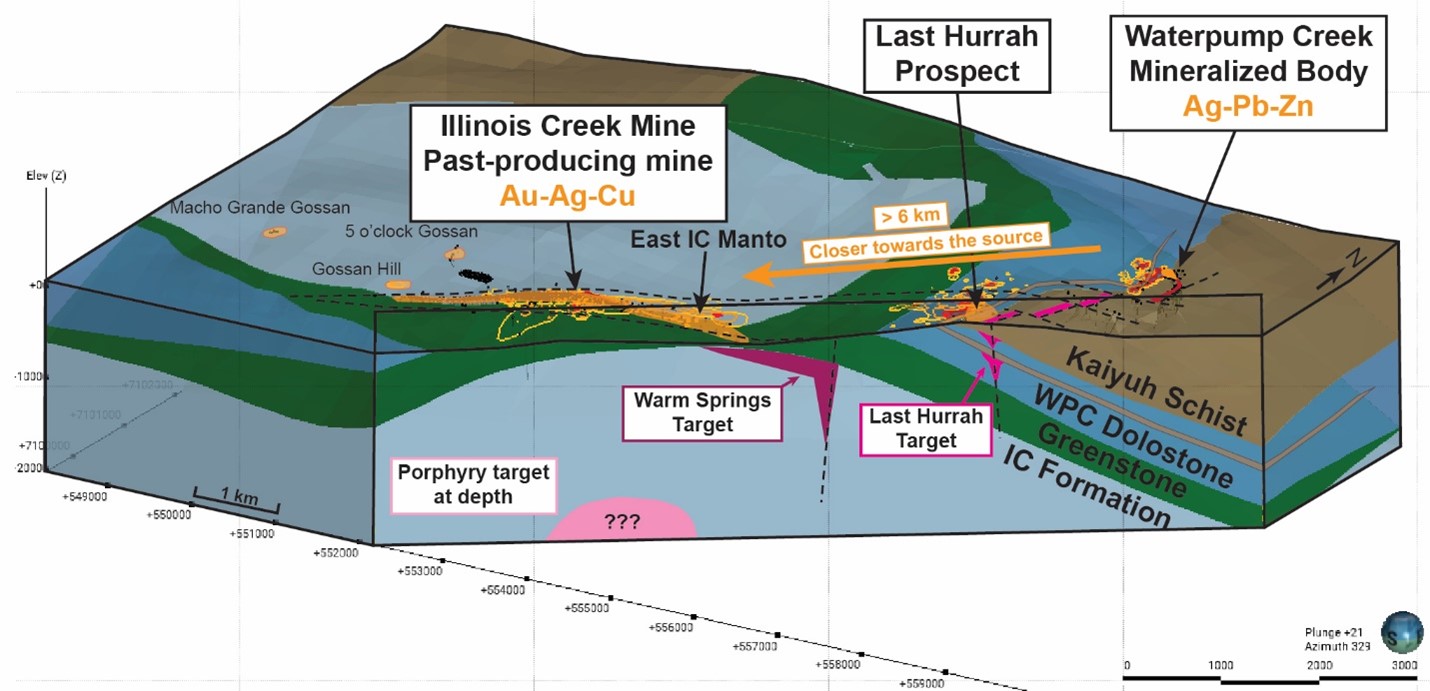
Click on image for larger 3D map of the geology, horizons, mineralization, and potential porphyry source along a six-kilometer trend from Illinois Creek to Waterpump Creek.
Western Alaska Minerals Corp. Dec. 7 reported that it is narrowing in on what appears to be a deeper horizon of silver-rich carbonate replacement deposit mineralization at the Last Hurrah target on the company's Illinois Creek property about 300 miles west of Fairbanks, Alaska.
CRD mineralization was discovered at the Waterpump Creek target on the Illinois Creek property by Anaconda in 1982 and was further investigated by Novagold Resources Inc. in the early 2000s. This work resulted in outlining an intriguing but small deposit – 166,000 tons of historical resource averaging 295 grams per metric ton silver, 16.1% lead, and 5.5% zinc.
In the final hole of its 2021 drill program, WPC21-09, Western Alaska cut 10.5 meters of CRD mineralization averaging 522 g/t silver, 22.5% zinc, and 14.5% lead. This hole put the company onto the southern extension of the Waterpump Creek deposit.
During 2022, Western Alaska significantly expanded the silver-rich mineralization to the south. Highlights include:
• 5.1 meters averaging 459 g/t silver, 12.1% zinc, and 14.8% lead in hole WPC22-07.
• 2.8 meters averaging 1,304 g/t silver, 2.5% zinc, and 37.1% lead in hole WPC22-13.
• 48.8 meters averaging 144 g/t silver, 9% zinc, and 5.5% lead in hole WPC22-17.
• 101.7 meters averaging 160 g/t silver, 5.4% zinc, and 5.3% lead in hole WPC22-18.
• 5.1 meters averaging 789 g/t silver, 14.9% zinc, and 22% lead in hole WPC22-21.
• 22.7 meters averaging 293 g/t silver, 20.3% zinc, and 9% lead in hole WPC22-22.
The 2023 program included five infill and resource expansion holes at Waterpump Creek and nine holes to rediscover the CRD mineralization at Last Hurrah that has been shifted by a fault that cut and displaced the mineralization.
Highlights from the infill and expansion drilling at Waterpump Creek include:
• 19.4 meters averaging 158 g/t silver, 11.5% zinc, and 5.3% lead from a depth of 145.1 meters; and 2.9 meters of 173 g/t silver, 13.9% zinc, and 6.7% lead from 176 meters in hole WPC23-0029.
• 22 meters averaging 146 g/t silver, 9.8% zinc, and 3.3% lead from a depth of 216.6 meters; eight meters of 47 g/t silver, 13.5% zinc, and 0.8% lead from 241.4 meters; and 40.2 meters averaging 262 g/t silver, 4.5% zinc, and 10.9% lead from 260.6 meters in hole WPC23-030.
With the results from WPC23-030, Western Alaska has traced the CRD mineralization at Waterpump Creek 495 meters to the fault that separates it from Last Hurrah.
"It is rare for a junior exploration company to control, in a stable mining jurisdiction, an entire, intact system of this scale, that even at this early stage is showing the hallmarks of a well-mineralized CRD system," said Western Alaska Minerals CEO Kit Marrs. "It took several tries with the drill bit at WPC, but once we intercepted the exceptionally high-grade silver-lead-zinc sulfides there, it took just two seasons of drilling to flesh out a substantial zone, justifying the calculation of an initial mineral resource estimate. Results to date suggest that WPC is just the fingertip of a six-kilometer-long mineralized trend that runs back to Illinois Creek, of which only 8% has been drill tested to date."
New Last Hurrah Horizon
Now, Western Alaska is focused on rediscovering the fault-offset continuation of Waterpump Creek in the Last Hurrah area so that they can continue tracing it along the 6,000-meter mineralized trend that leads back to the past producing Illinois Creek gold-silver deposit.
The nine holes drilled in the Last Hurrah area this year encountered broad zones of CRD alteration with dispersed mineralization that correlates well with geophysics carried out over the area but did not tap into the massive sulfide extension of Waterpump Creek.
Ultraviolet fluorescence, which has proven to be a useful tool for vectoring toward CRD mineralization at Waterpump Creek and other similar deposits, indicates that the Last Hurrah drilling is in the right area.
When the core from drilling close to the Waterpump Creek CRD is put under UV light, mineralization shows up with intense pink and orange fluorescence – holes nearest the CRD have the most intense fluorescence. The drill core that fluoresces the most intensely has been dubbed "Barbeque Rock" due to its resemblance to hot coals.
Hole LH23-0005 cut a zone of BBQ rock very similar to what was observed last year in WPC22-021, a Waterpump Creek hole that was 30 meters away from the high-grade CRD mineralization cut in hole WPC22-022.
"It is always exciting to see this strength of BBQ fluorescence response in 'fugitive calcite' veining in a new area. It says you're getting into the halo around something important," said Peter Megaw, a Western Alaska Minerals technical advisor and expert on CRD mineralized systems.
Two holes that drilled through an impermeable schist at Last Hurrah hit similar alteration in a deeper limestone unit, providing another potential horizon of CRD mineralization at Last Hurrah.
Western Alaska says this new geologic recognition, combined with advanced remodeling of a high-resolution 3D geophysical survey covering both Waterpump Creek and Last Hurrah, is helping to determine the structural and stratigraphic controls on mineralizing fluid migration from the probable porphyry source near the Illinois Creek Mine, through Last Hurrah, and onward to Waterpump Creek.
"With our updated understanding of the system, we are excited to be zeroing in at Last Hurrah and continuing to trace high-grade mineralization back towards Illinois Creek," said Marrs.
The progression from higher-temperature fluids depositing copper, gold, and silver at Illinois Creek to lower-temperature fluids depositing silver, zinc, and lead at Waterpump Creek is indicative of a district zonation pattern typical of porphyry to CRD systems.
Western Alaska Minerals Corp.
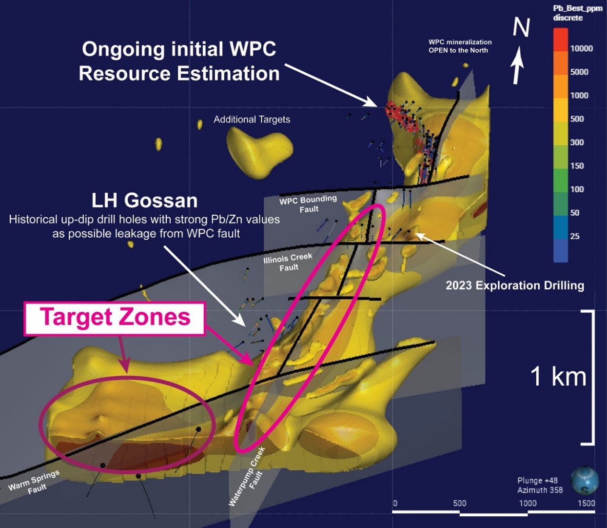
Click on image for larger Dias 3D induced polarization geophysical survey map with target zones at Last Hurrah.
Western Alaska says this progressive metal zonation with alteration and mineralization occurring in multiple and progressively higher stratigraphic stair step levels demonstrates the excellent potential of the Illinois Creek District as a large-scale CRD system.
"Continuity of mineralization from the source outward with gradually diminishing volume, often over several kilometers, has been recognized for over 100 years as a fundamental aspect of CRD systems, so it is highly probable we'll find the continuation of Waterpump Creek mineralization across the post-mineral fault," said Megaw. "Importantly, many CRD systems show 'Christmas Tree' patterns of mineralization affecting more and more layers in the stratigraphy as the source is approached and it looks like we're beginning to see that progression at Last Hurrah."

Over his more than 16 years of covering mining and mineral exploration, Shane has become renowned for his ability to report on the sector in a way that is technically sound enough to inform industry insiders while being easy to understand by a wider audience.
- Email: [email protected]
- Phone: (907) 726-1095
- https://www.linkedin.com/in/shane-lasley-ab073b12/


Reader Comments(0)